Loading... Please wait...
Huge range of New Marine electronics for sale , Cheap boat electronics for sale
Categories
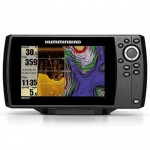
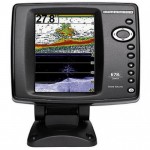
 New Products
-
 $799.00
-
 $3,040.00
-
 $380.00
-
 $2,327.00
-
 $2,944.00
Our Newsletter

- Home
- Garmin Marine Electronics
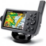
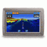
- Garmin Gpsmap 640 Land & Sea Gps Navigation Sys. W/ Preloaded Us Road Maps & Marine Charts
Garmin Gpsmap 640 Land & Sea Gps Navigation Sys. W/ Preloaded Us Road Maps & Marine Charts


Product Description
Garmin Gpsmap 640 Land & Sea Gps Navigation Sys. W/ Preloaded Us Road Maps & Marine Charts
With the Garmin GPSMAP 640, you’ll get a full-featured marine chartplotter and an on-the-road navigator that comes ready to go with preloaded BlueChart g2 data and City Navigator NT road maps for North America. The GPSMAP 640 comes standard with a high-sensitivity GPS receiver and brilliant, high-resolution touchscreen display so you’ll always know the way whether you’re on land or at sea.
Powerful and Portable
Featuring a marine and an automotive mode, a high-sensitivity GPS receiver, and a rugged case with waterproof (IPX7) design, the GPSMAP 640 is ready for your next outing. The GPSMAP 640 effortlessly shifts gears between marine and automotive modes. When supported by the marine mount, you’ll have at-a-glance access to your marine data. And when placed in the automotive mount, the automotive mode is automatically activated and the GPSMAP 640 becomes a robust street navigator.
Designed to Shine
With a brilliant 5.2-inch WVGA touchscreen display, and an intuitive interface, you’ll have everything you need to navigate with confidence. The GPSMAP 640 comes preloaded with BlueChart g2 data and other surface features as well as City Navigator NA maps that include coverage maps for the United States, Puerto Rico and select parts of Canada.
Stay in the Know
The GPSMAP 640 can receive XM WX satellite weather data in marine mode and XM NavTraffic information in automotive mode with optional GXM 40 antenna and XM subscription. With all that information at your fingertips, you can avoid bad weather at sea or traffic tie-ups on the road. The GPSMAP 640 also supports XM audio so you’ll always have music to enjoy while you’re on the go.
By Sea
In marine mode, the GPSMAP 640 brings you tides and currents, depth contours, navaids, port plans, marine services and points of interest (POIs) via preloaded BlueChart g2 marine data. And with optional BlueChart g2 Vision cards, you’ll get 3D “mariner’s eye view” above the waterline and “fish eye view” below the waterline. You’ll also benefit from Auto Guidance technology that searches chart data to suggest the best passage. The GPSMAP 640 is also NMEA 0183 compliant, so it can be easily added to an existing marine network.
By Land
In automotive mode, the GPSMAP 640 announces street names with spoken turn-by-turn directions pulled from the preloaded City Navigator NT road maps for North America. And route planning has never been easier. Whether you’re searching for boat shops or bait shops, you’ll be able to plan the quickest and most efficient route. You can also create custom points of interests (POIs) and set up proximity alerts to let you know what’s in your path as you travel down the road.


Customers Who Viewed This Product Also Viewed
-
 $313.00
-
$380.00
-
 $180.00
-
$3,040.00
-
$2,327.00
-
 $228.00
-
$2,944.00
-
 $256.00
-
 $199.00
-
 $3,752.00