Loading... Please wait...
Huge range of New Marine electronics for sale , Cheap boat electronics for sale
Categories
 New Products
-
 $799.00
-
 $3,040.00
-
 $380.00
-
 $2,327.00
-
 $2,944.00
Our Newsletter

- Home
- Garmin Marine Electronics
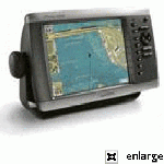
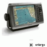
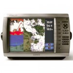
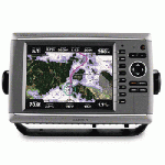
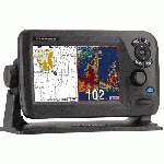
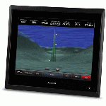
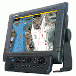
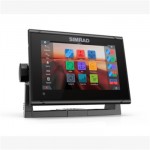
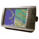
- Garmin Gpsmap 6212 Big-screen Network Chartplotter W/ Coastal Maps
Garmin Gpsmap 6212 Big-screen Network Chartplotter W/ Coastal Maps


Product Description
Garmin Gpsmap 6212 Big-screen Network Chartplotter W/ Coastal Maps
The GPSMAP 6212 brings unprecedented speed to your vessel with Garmin G Motion technology – the future of marine technology today. With blazing-fast map redraw and refresh rates, you’ll have near real-time data to guide you. Whether you’re in a crowded harbor or in uncertain weather, you’ll have the confidence you need to navigate your surroundings with the GPSMAP 6212 as your guide. The GPSMAP 6212 is also compatible with an optional remote for added flexibility. And with a sleek and stylish design that was built to brave the elements, the GPSMAP 6212 looks great in any helm.
The GPSMAP 6212 features highly detailed BlueChart g2 marine cartography of the coastal United States, including Alaska, Hawaii and the Bahamas. And for more detail, you can easily add maps with the SD™ card slot without having to connect to a computer. The GPSMAP 6212’s high-speed processor draws maps quickly, and its simple intuitive interface makes navigating easy. To keep tabs on your engine room or other area of your boat, you can also connect a live video feed with the GPSMAP 6212’s video input and output options. The GPSMAP 6212 also comes standard with a wide range of brightness options – from sunlight-readable to low-light conditions, you can adjust the setting to match the your surroundings.
Garmin Gpsmap 6212 Big-screen Network Chartplotter W/ Coastal Maps
- High-resolution satellite imagery when overlaid on the chart, will provide the mariner with unparalleled situational awareness
- Aerial reference photography provides “real world” photos of ports, harbors, marinas, waterways, navigation landmarks and other points of interest, offering the mariner another powerful tool for navigating unfamiliar waters
- Mariner’s Eye view – Provides the mariner with a 3-D perspective of chart information for a quick, reliable and easy position fix.
- Fish Eye view – 3D perspective below the water line for displaying bottom contours based on bathymetric charting data
- Auto guidance technology will search the attributes of all relevant charts to suggest the best course for navigation
- Fishing charts, tides, currents, marine services, coastal roads and points of interest detail
The GPSMAP 6212 easily connects to your network – providing system integration so you can interface with additional MFDs and add remote sensors. Once connected, you can share information between the GPSMAP 6212 and other chartplotters on your boat. You can also add high-powered radar, sonar and XM satellite weather and radio to your system.
Garmin Gpsmap 6212 Big-screen Network Chartplotter W/ Coastal Maps
- GPSMAP 6212
- Top & bottom snap covers
- Bail mount & knobs
- GPS 17x NMEA 2000 (with pole mount, flush mount and under deck mount adapters)
- Protective front cover
- Power cable
- Video cable
- NMEA 0183 cable
- NMEA 2000 drop cable
- NMEA 2000 10 m backbone cable
- NMEA 2000 power cable
- NMEA 2000 T-connector & terminator kit
- Flush mount hardware
- Flush mount gasket
- Marine grommet kit
- Manual case with user documentation


Customers Who Viewed This Product Also Viewed
-
 $285.00
-
 $2,042.00
-
 $4,322.00
-
 $180.00
-
 $379.00
-
 $522.00
-
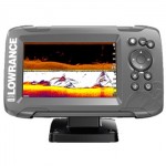
 Lowrance 000-11652-001 Elite-5 Chirp Fishfinder chartplotter Gold – 83/200 And 455/800 Transom Mount$237.00
-
 $1,139.00
-
 $399.00
-
 $190.00