 Loading... Please wait...
Huge range of New Marine electronics for sale , Cheap boat electronics for sale
- Home
- Shop Marine Electronics
- Furuno Marine Electronics
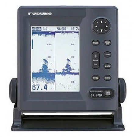
- Furuno Ls6100 Echosounder
Furuno Ls6100 Echosounder
Product Description
Furuno Ls6100 Echosounder
- Waterproof, 6 Inch, Silver Brite Monochrome LCD Display
- Targets presented in up to 4 gray tones
- Picture resolution of 240(H) x 320(V) pixels
- 300 Watt RMS (2400 P-P) output power
- Seven depth scales, from 0-10 to 0-640 feet
- Depth offset to 1,500 feet, maximum depth scale of 3,000 feet
- Automatic or Manual Depth Range and Gain Adjustment
- A-Scope for rapid fish detection and species identification
- White Line Mode for enhanced bottom fish detection
- Audible and Visual, Temp, Speed, Fish or Bottom Alarm
- TLL output sends position, temp and depth to Furuno TLL capable plotters
- Multiple Display Modes 1. Normal, Low Frequency/High Frequency 2. Dual Frequency 3. Bottom Lock Expansion 4. Marker Zoom 5. Bottom Zoom 6. A-Scope 7. Two Customizable Navigation Data Display – Displaying digital and analog graphical info, including: Wind Speed/Direction, Ship’s Speed, Steering Screens and more
- Speed and Temperature input via optional sensor or NMEA data
- Direct connection of BBGPS or BBWGPS antennas for GPS or WAAS fix
- Mini Navigator allows storage of up to 12 waypoints, with capability to navigate back to these points using the LS6100’s XTE/Range and Bearing calculation and steering screens
- Two NMEA0183 ports – one bi-directional and one “listen-only”
Furuno Ls6100 Echosounder
- 5 Lbs., 1 Carton Less Transducer
Furuno Ls6100 Echosounder
- 12 VDC, 10 Watts
Furuno Ls6100 Echosounder
- 10 pin
Furuno Ls6100 Echosounder
Furuno’s LS6100 fish finder is compact, waterproof and best of all powerful. It packs 300 Watts (2,400 p-p) of output power for unparalleled fish finding performance.
The LS6100 offers dual frequency capabilities – both 50 and 200kHz – for a two-way view of the world below your boat. This unit is compact enough to fit practically anywhere. Yet it features a 6″ silver brite LCD display that offers a remarkably detailed picture of fish and bottom structure.
In addition to it’s fish finding capability, the LS6100 has the unique ability to be a handy navigational organizer when connected to appropriate sensors. It can display a variety of information including: water temperature, wind direction/speed, Lat/Lon, XTE and distance run in a graphical or text format. With the BBGPS or BBWGPS receiver connected, the “Mini-Navigator” feature is capable of storing up to 12 waypoints with programmable names. Any waypoint can be selected as a destination.
Customers Who Viewed This Product Also Viewed
-
$427.00

-
$617.00

-
$313.00

-
$332.00

-
Lowrance 000-11652-001 Elite-5 Chirp Fishfinder chartplotter Gold – 83/200 And 455/800 Transom Mount$237.00

-
$380.00

-
$569.00

-
$285.00

-
$2,944.00

-
$522.00


